
I’ve always been interested in the history of food, particularly as it might relate to the periods in which my novels are set. A year and a half ago, because I was interested in breadmaking during the Civil War, I wrote an article on the history of chemical leavening in breadmaking which you can access here.
Now that school is out, I’ve got a little more time to play with historical recipes, and I’m back to making old fashioned breads. One I found curious, Salt-Rising Bread, appeared in my James Beard Cookbook, Beard on Bread. Beard called this recipe one of the oldest bread recipes in America, and included it as more of a curiosity than a successful bread. He warned that it could be temperamental and unreliable, but that just piqued my interest, so I had to do a little more research and then give it a try.
Now that school is out, I’ve got a little more time to play with historical recipes, and I’m back to making old fashioned breads. One I found curious, Salt-Rising Bread, appeared in my James Beard Cookbook, Beard on Bread. Beard called this recipe one of the oldest bread recipes in America, and included it as more of a curiosity than a successful bread. He warned that it could be temperamental and unreliable, but that just piqued my interest, so I had to do a little more research and then give it a try.
Before the 1860s, when commercial yeast was developed, women had to rely on native yeasts (which are a form of fungus) or bacteria to leaven their baked goods. The leavening in Salt-Rising Bread is Closridium perfringens, a bacteria that can cause food poisoning but is rendered harmless by baking. Salt-Rising bread seems to have been developed in the late 1700s by pioneers in the Appalachian mountains. It is still produced in Kentucky, West Virginia, Western New York, and Western Pennsylvania. While this area does not include Gettysburg, where my novel The Bent Reed is set, it is close enough that it might have been baked there. It's also highly probable that the women of Gettysburg, like the women in every town and city in America, collected their own local funguses and bacteria to make similar recipes.
No one seems to know why this bread is called Salt-Rising. It does not taste salty, have an unusual amount of salt in it, and salt does not leaven the bread. One source suggested that early settlers kept the starter warm in a bed of heated salt. Another suggested that the salt inhibited yeast growth, allowing other leavenings to grow. I wonder if people just didn't know what leavened the bread, thinking it was the salt instead of bacteria from the potatoes.
No one seems to know why this bread is called Salt-Rising. It does not taste salty, have an unusual amount of salt in it, and salt does not leaven the bread. One source suggested that early settlers kept the starter warm in a bed of heated salt. Another suggested that the salt inhibited yeast growth, allowing other leavenings to grow. I wonder if people just didn't know what leavened the bread, thinking it was the salt instead of bacteria from the potatoes.
The starter for salt-rising bread grows in less time than traditional sourdough, but at a higher temperature. Several recipes I looked at said the starter needed to be held at 38-45°C (100–113 °F) for between 6 and 16 hours. James Beard’s recipe suggested waiting 12 to 24 hours. My batch developed a head of foam 15 hours after I began it. Several sources warned that the starter would smell like very ripe cheese. I found that it smelled more like the socks a teenaged boy brought back from scout camp. I do not recommend you have friends with sensitive noses over while you allow your starter to develop.
To make a Salt-rising starter, place 1 1/2 cups hot water, 1 medium potato, peeled and sliced thin, 2 TBS cornmeal, 1 tsp sugar and 1/2 tsp salt into a 2 quart mixing bowl and cover with a lid. If you are going to do this the old fashioned way, place the jar in a bowl filled with boiling water and cover with quilts. A more modern way to do the same thing is to place the jar in an electric oven with the light on, or a gas oven with the pilot light on. Let stand for between 12 and 24 hours, until the starter has developed at least 1/2 inch of foam.
To make a Salt-rising starter, place 1 1/2 cups hot water, 1 medium potato, peeled and sliced thin, 2 TBS cornmeal, 1 tsp sugar and 1/2 tsp salt into a 2 quart mixing bowl and cover with a lid. If you are going to do this the old fashioned way, place the jar in a bowl filled with boiling water and cover with quilts. A more modern way to do the same thing is to place the jar in an electric oven with the light on, or a gas oven with the pilot light on. Let stand for between 12 and 24 hours, until the starter has developed at least 1/2 inch of foam.

To turn the starter into bread, strain the starter over a mixing bowl. Pour 1/2 cup warm water over the potatoes in the strainer, then press down with the back of a spoon to release as much of the potato’s moisture as possible. Throw away the potatoes.
Add to the mixing bowl 1/4 tsp baking soda, 1/2 cup undiluted evaporated milk, 1 TBS melted butter, 1 tsp salt, and 2 cups of flour. Beat until very smooth. Continue adding up to 2 1/2 cups more flour, a cup at a time, until you have a soft dough.
Place a cup of flour on the counter. Turn your dough out of the bowl and knead it into the flour until the dough is smooth and soft. Shape into a loaf and place in a well buttered pan. Brush loaf with melted butter, cover with a piece of buttered (I use spray cooking oil) plastic wrap, and place in a warm, draft-free place to rise. I have a double oven, so I put it back into the oven with the light on. Rising may take as much as 4 or 5 hours.

Bake in a preheated oven at 375° for 35-45 minutes. Remove from pans to cool.
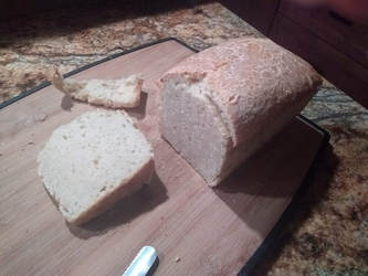
The resulting loaf had a very fine texture, but the top crust pulled away from the loaf. It had a slightly tangy taste to it, and was excellent with butter and toasted. It reminded me more of beer batter bread than traditional yeast bread, but I think it would be a good breakfast bread, and an excellent accompaniment to a hearty stew.
Jennifer Bohnhoff has written four novels set in the Civil War: The Bent Reed and the Rebels Along the Rio Grande trilogy.


