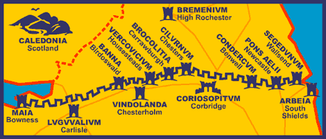
Hadrian's Wall is a stone wall that spans the English countryside and (basically) separates England from
Scotland. Beginning in the east on the River Tyne, it stretches all the way to the Solway Firth in the west, a distance of 80 Roman miles, or nearly 73 modern miles. Hadrian's Wall served as the northern boundary of the Roman Empire in Britain, but it was not the limit of Roman influence.
Romans first arrived in Britain in 55 B.C., when Julius Caesar landed two legions on the coast of Kent. He returned the following years with 800 ships, five legions and 2,000 cavalry. This time, he managed to force the British warlord Cassivellaunus to pay tribute to Rome and he set up a client king named Mandubracius, of the Trinovante Tribe. Caesar included accounts of both invasions in
Commentarii de Bello Gallico, or his Commentary on the Gallic Wars. This text contains the earliest surviving significant eyewitness descriptions of the island's people, culture and geography.
The true conquest of Britain began in earnest in AD 43 under Emperor Claudius. By AD 87, most of what we now call England, Cornwall and Wales was under Roman control. In the north, a Roman road known as the Stanegate marked the northern boundary of the Empire. Stanegate, which means "stone road" in a Northumbrian dialect, is not the original, Roman name of the road, which has been lost to history.
The road is believed to have been built under Governor of Agricola, from 77 to 85 AD, during the reigns of the emperors Vespasian, Titus, and Domitian. Along the Stanegate, forts, including Vindolanda (Chesterholm) were spaced at one-day marching intervals, or 14 Roman and 13 modern miles. Corstopitum (Corbridge) and Luguvalium (Carlisle), guarded important river crossings.
Something happened in 119 AD that challenged Rome's authority over her northern border. Although information is scant and sketchy, it appears that a local rebellion led to the deployment of Legio VI Victrix to assist in suppressing the resistance.Soon after, Legio VI Victrix replaced the Legio IX Hispana in their quarters at Eboracum (York). No one knows what happened to the IX, but a vague correspondence between an ancient historian named Fronto and emperor Marcus Aurelius describes the strength of the Celtic forces and how many Roman soldiers lost their lives, and may refer to something that happened during this period. The Ninth Legion disappears from the historic record about this time, but whether they were annihilated in a battle with a British tribe or transferred out of Britain is a mystery. In the 1800s,German historian Theodor Mommsen theorized that the Celts in northern England, particularly the Brigantes, caused the demise of the Ninth . In her bestselling novel, The Eagle of the Ninth, British author Rosemary Sutcliff suggested that the Ninth fell victim to the wilderness and native hostility beyond Hadrian’s Wall. I read this historical novel when I was in the 4th grade and credit it with my love both for historical fiction and for Iron Age Britain.
Whatever happened, British Governor Quintus Falco invited the Emperor Hadrian to visit Britain, in 122 and that led to the building of the wall about a mile north of the Stanegate that bears Hadrian's name. Perhaps Hadrian's Wall was built so that there would be no more disasters like the one that might have befallen the Ninth Legion. Perhaps the wall is just a massive monument to the power of Rome. Whatever it was intended to be, it is an impressive architectural feat.
The wall spans the width of northern England. It served both as a defensive fortification and as a customs facility, regulating trade and travel between the Roman provinces and the outlying areas. Gates we now call milecastles, since they were spaced about a Roman mile apart, contained garrisons that housed a few dozen men. In between each pair of milecastles were two towers, also staffed by soldiers on patrol along the wall.
The wall took six years to construct. The wall was not the same consistency throughout. In the west, the wall was 11 feet high, 20 feet wide, and made mainly of turf. In the east, the wall was 15 feet high, 10 feet wide, and made of stone. The construction of the wall was not a "one and done" prospect, and there is evidence in the stonework that the wall's configuration, including that of the milecastles and watchtowers along it, were often reconfigured. Some historians believe that the wall had crenelations along it. Others believe the walkway was exposed. There is also some evidence that the wall was whitewashed. What a statement a long, white ribbon of stone would have made as it wound itself through the hills!
The Wall was not built by slaves or by local people, but by the army. Keeping soldiers busy with building and road projects was one of the ways Rome kept its soldiers strong, healthy, and out of trouble. Legio II Augusta, Legio VI Victrix, and Legio XX Valeria Victrix left many inscriptions along the wall, demonstrating which sections they had worked on. Each legion consisted of about 5,000 infantrymen. There is evidence that auxiliary units – the other main branch of the provincial army – and even sailors from the Roman British fleet helped on some portions of the wall. While they built the wall, the Legions did not occupy it. Once they had finished construction, Legio II Augusta moved to their base at Isca Augusta (modern Caerleon), Legio VI Victrix to its base at Eboracum (York), and Legio XX Valeria Victrix to Camulodunum (Colchester), leaving maintenance and garrisoning of the wall to the auxiliary forces.About 10,000 soldiers filled the 14 forts along the wall, including cavalry units of 1,000 troops stationed at either end.
The western and eastern portions of the wall have largely disappeared over time, with many of their stones being pilfered for medieval and modern building and road projects. Although the road projects have been covered in asphalt and cannot be seen, there are many houses and churches along the wall that have stones whose inscriptions show they were clearly once part of the wall. Much of the center portion of the wall, which runs through wilder and less populated land
, still stands.  The wall and its milecastles and watchtowers does not stand alone. A large earthen rampart-and-ditch combination called the Vallum runs south of the Wall. This earthwork had a ditch that was 20 feet across and 15 feet deep. Archaeologists are still not certain what the purpose of the Vallum was, but it might have been the southern boundary of a military zone that included the Wall and the series of defensive ditches and berms on the northern side of the wall.
 Hadrian's Wall was not the limit of Roman influence in Britain. When Hadrian died in AD 138, his successor, Antoninus Pius moved the frontier north to the Forth–Clyde isthmus and built a new, turf wall. Later, four advance forts, each holding a 1,000-strong mixed regiment of infantry and cavalry, an irregular unit, and scouts were built north of the Wall. Hadrian's Wall continued to be occupied by the Romans for nearly 300 years, and the remains continue to awe visitors.


.jpg "Poltross Burn Milecastle (48) reconstructed.")


