
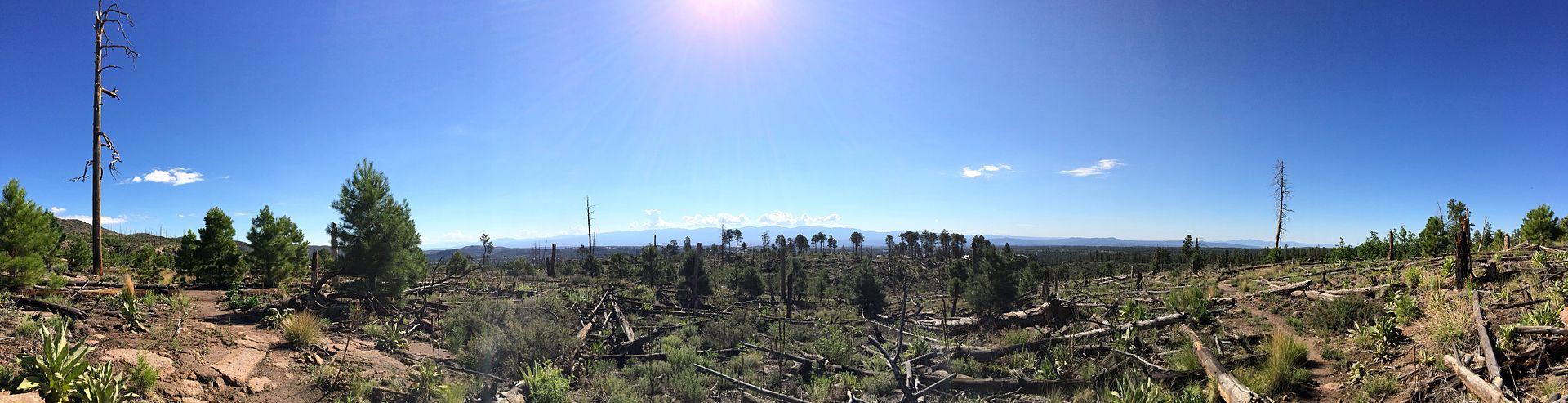
Fourteen years after the Cerro Grande fire, devastation on the Quemazon Trail west of Los Alamos is still obvious. This image was obtained from http://www.gao.gov/new.items/rc00257t.pdf, a document titled "T-RCED-00-257 Fire Management: Lessons Learned From the Cerro Grande Fire", Public Domain
In May of 2000, a disastrous forest fire that came to be named The Cerro Grande Fire began in the hills above the town of Los Alamos, New Mexico. By the time it was contained, it had burned many homes, threatened national security, and destroyed the lives of many people.
The fire started as a controlled burn high on Cerro Grande, a 10,200-foot summit covered with a mix of ponderosa pine, douglas fir, white fir, and aspen trees. The summit, which sits on the rim of the Valles Caldera, has a rincon, or meadow on its southern slopes. The United States Forest Service chose that rincon as the starting place for a controlled burn that was part of a 10-year plan for reducing fire hazard within Bandelier National Monument. That rincon is the headwaters of Frijoles Creek, which flows southeast into the Rio Grande. It is close to New Mexico State Road 4, the main highway through Los Alamos County.
The fire started as a controlled burn high on Cerro Grande, a 10,200-foot summit covered with a mix of ponderosa pine, douglas fir, white fir, and aspen trees. The summit, which sits on the rim of the Valles Caldera, has a rincon, or meadow on its southern slopes. The United States Forest Service chose that rincon as the starting place for a controlled burn that was part of a 10-year plan for reducing fire hazard within Bandelier National Monument. That rincon is the headwaters of Frijoles Creek, which flows southeast into the Rio Grande. It is close to New Mexico State Road 4, the main highway through Los Alamos County.
 The smoke from the fire made it all the way to Oklahoma. Public Domain, https://commons.wikimedia.org/w/index.php?curid=10523496
Spring may not be the best time to start controlled burns in the Jemez. High winds are common during this time of year. In addition to that, the forests were extremely dry but filled with undergrowth. In the early-to-mid-1990s, the Jemez had received abnormally high precipitation, leading to an explosion of luxuriant undergrowth. Then, several years of severe drought had dried out the forest. Deadfall, trees that had died and laid on the ground, had a moisture content lower than that of well-cured firewood. Conditions were ideal for a major forest fire. However, officials worried that if controlled burn were not used to clear the forest, a lightning strike or human carelessness could lead to disaster. Officials decided that a controlled burn was safer than letting nature take its course. The burn was scheduled to begin late in the evening of May 4, 2000.
Just after the burn had begun, the winds picked up. By May 5th, the fire had burned through its controllines on the east side. The burn was declared a wildfire that afternoon. By May 7th, the fire’s behavior had become increasingly erratic, with spotting, the creation of new fires, due to flying embers, becoming common. Los Alamos National Laboratory shut down operations on May 8. Two days later, the town of Los Alamos was evacuated. That evening, 235 homes in Los Alamos were destroyed.

By the time the fire was declared officially contained, on June 6, over 400 families had lost their homes and over 43,000 acres had been burned. Los Alamos National Laboratory suffered from destruction or damage to its structures, but none of the special nuclear material housed there was destroyed or damaged. Luckily, there was no loss of human life. The US General Accounting Office estimated total damages at $1 billion. The Cerro Grande fire was declared extinguished on July 20, 2000.
But even if the fire was no longer threatening Los Alamos, life could not go back to normal. Scientists determined that the soil beneath a layer of ash or burned soil had become hydrophobic, or water repellant. Los Alamos, the laboratory, and the lower parts of the burned area are all situated on the Pajarito Plateau, an area which has a lot of canyons that concentrate surface runoff. When the monsoon rains which usually begin in July occurred, it was highly likely that the hydrophobic soil would result in serious flash flooding. Diamond Drive, one of the town's arterial roads, was damaged in such a flood.
These floods also created serious erosion issues, especially along the 57 miles of trails that had become clogged with fallen trees and boulders washed down from higher elevations. A volunteer task force devoted many thousands of hours to rebuilding trails and planting trees. Local school children made many thousands of "seed balls" to broadcast in the burned areas, and about 7000 hydromulching and hydroseeding flights occurred during the month of July. Water quality had to be monitored for several years after the fire.
 A FEMAville in Greensburg, Kansas photo by Jackie Langholz
In order to house people who had been burned out, the Federal Emergency Management Agency (FEMA) brought in portable buildings, or trailers. The trailers weren’t available until June because they not only had to be delivered, but hooked up to municipal utilities that had to be extended out to undeveloped land near the county rodeo grounds on North Mesa. Known locally as FEMAville, the complex housed hundreds of displaced residents. In 2006, when the trailers were removed, most of the displaced residents had been settled into new homes, although reconstruction of houses in the burned area continued for several years after that.
Wildfires have grown increasingly common in the years since the Cerro Grande fire, and they continue to be a source of great controversy, especially when they begin through government action.
Jennifer Bohnhoff is an author of books for middle grade through adult readers. She lives in the fire-prone mountains of central New Mexico. Her next book, Summer of the Bombers, is scheduled to come out on April 10th. The story of a girl who loses both her home and her horse because of a controlled burn gone rampant, it is based loosely on the Cerro Grande fire.


No comments:
Post a Comment