Saturday, July 19, 2025

My visit to Isle Royale


During the summer of 2000, my husband, three sons, and I went to Isle Royale National Park. If you have never been to Isle Royale, you're not alone. One of the least visited national parks in the United States, it attracts only around 25,000 visitors per year. In comparison, Yellowstone National park had 4.74 million visitors in 2024, and Great Smoky Mountains, the most popular national park in the United States, attracted over 12.1 million visitors.

One reason this park is so undervisited is because it's a challenge to reach. An island in Lake Superior, it can only be visited by boat or seaplane. Private boats can come to the Isle, but we, like most visitors, took a ferry. The Voyageur II runs from Grand Portage, MN.  It and its sister ship, the Sea Hunter III, reach Windigo in about 2 hours, but the Voyager continues on, traveling to Rock Harbor in about 8 hours. All along the way, it picks up and drops off passengers and, back when we traveled, mail and supplies for Islanders. Another company, The Royale Line, runs from Copper Harbor, MI, to Rock Harbor in 3.5 hours, and the Park Service (nps.gov/isro) runs the Ranger III from Houghton, MI, to Rock Harbor in about 6-hours.Isle Royale Seaplanes flies from Hancock, MI, and Grand Marais, MN, to Windigo or Rock Harbor.

Because of the severity of conditions on Lake Superior, the park is only open from mid-April through October. Weather can be unsettled in spring and fall; stormy conditions on Lake Superior affecting transport. Both Rock Harbor and Windigo have visitor centers that can help you orient and educate yourself, and can rent canoes and other supplies. They are open daily in season, with reduced hours outside of July and August. A visitor center at park headquarters in Houghton, Michigan is open year-round.

Once you've arrived, you'll find that Isle Royal is very rustic. 45 miles long and 9 miles wide, it has just one hotel, the Rock Harbor Lodge. The lodge's room have private baths, plus there is a dining room and a dockside store. Windigo has rustic one-room cabins, and there are 36 campgrounds scattered throughout the shores, and lakes, and promontories of the island. 17 of these campsites can accommodate larger groups.Some are nothing more than a flat spot and a fire ring, while others have three sided cabins, the fourth side covered in screen to keep out the mosquitos. We carried tents, sleeping bags and a backpacking stove, but welcomed the one cabin we came to during our five day trek. Non-fee permits are required for all camping and overnight boat docking or anchoring. Parties of 1 to 6 get permits on arrival but cannot reserve any specific sites. Groups of 7 to a maximum of 10 must reserve sites and obtain permits in advance through park headquarters.


Isle Royale National Park was designed to be a wilderness. It has no roads. If you want to travel the
island, you use one of the many foot trails, or a network of water routes for canoes and sea kayaks.The Greenstone Ridge Trail begins at Rock Harbor and follows the island's rocky spine, connecting numerous trails that drop off towards both the southern and northern shores in a web of hiking possibilities. This picture if of my three boys sitting on the granite rock at the island's highest point. 

We landed at Rock Harbor, where we rented three canoes for the five of us. Our youngest was just six, and we would have liked to have only rented two canoes, but regulations forbid three people in any boat. Because of the nature of the landscape, we found ourselves hiking the fingers of land on the east side of the island, while portaging our canoes, then paddling across the inlets. This proved to be tricky, since only my husband and my oldest son were strong enough to portage a canoe. While the two of them hefted the canoes, my middle son and I carried all of our gear, which was stored in five backpacks, while the youngest loaded himself up with all our life vests and waddled his way to the next shore. Some of the portages were over a mile, and we had to cross back and forth several times to transfer all the equipment. 

We never got out into Lake Superior itself, which can be too rough for canoes. If we had, we might have been able to look down at some of the shipwrecks that ring the island, grim monuments to rocky reefs and shifting fog. Some people scuba dive down to these wrecks.

We had a wonderful time on Isle Royale, but it was something that happened as we were leaving that
inspired me to write Perspective. The ferry had stopped near a rustic cabin that sat on the waterfront, and one of the sailors was handing mail and a box of groceries to a woman onshore. When I said that I'd like to own a cabin on the island, someone explained to me that it was impossible. When the island became a national park in 1940, some (but not all) of the people who owned land on the island were granted life leases. That allowed them to continue using their cabins until the grantee died. In 2000, it had been 60 years since those leases were granted, and most of the grantees were growing old. In the years since, they've died off, and the park service has taken control of the land. It made me wonder what it would have been like to be one of the families that lived on the island, and that wonder became the seed for a whole novel. 

Monday, July 14, 2025

Peaches and Cream Baked Oatmeal


 I've been busy editing my cowboy romance and prepping my middle grade historical novel for a fall publication, but then my sister arrived with two flats of peaches! Heather lives in Alamogordo, some 200 miles south of me, and her spring starts nearly a month before mine does. Her summer lingers well after I've gotten my first frost, too. It's paradise for sunbirds and for gardeners, as long as they don't mind the heat!

Two flats of peaches aren't going to just sit around on my counter as I write, so I took a break before the fruit flies invaded. I've now got five bags of peaches in the freezer, we've had fresh peaches for breakfast, lunch and dinner the last couple of days, and I've made a peach cobbler, a peach upside down cake, two peach pies, seven jars of jam, and I've tried one new recipe: a breakfast dish that can be served room temperature or warm from the oven. It was so good that I decided to share it with you. 

Peaches and Cream Baked Oatmeal tastes like it should be dessert, and I guess it could be if served with a dollop of ice cream or whipped cream. But it's pretty healthy, fairly low in sugar and fat, so why not enjoy it at breakfast time? I made it in advance, so that I could eat it right after coming home from the pool, where I swim a mile during the 6 am session. 

Peaches and Cream Baked Oatmeal

  • 1 1/4 cup nonfat milk, plus 1 TBS, divided
  • 1/4 cup sugar, plus 1 TBS, divided
  • 1 egg
  • 2 TBS butter, melted
  • 2 tsp vanilla extract, divided
  • 2 cups old fashioned rolled oats
  • 1 tsp baking powder
  • 1/4 tsp. salt
  • 1 cup peeled and diced fresh peaches
  • 4 oz. nonfat cream cheese, softened
  • 3 TBS peach jam

Preheat oven to 350°. Coat an 8" baking dish with cooking spray.

Whisk 1 1/4 cups milk, 1/4 cup sugar, 1 egg, melted butter and 1 tsp vanilla together in a large bowl until smooth and the sugar is dissolved. Add the peaches, baking powder, salt and stir well. Pour mixture into the prepared baking dish and let stand for 15 minutes to let the oatmeal soak in the milk a bit. 

Combine cream cheese, 1 TBS milk, 1 TBS sugar and 1 tsp vanilla and beat together until smooth and creamy. Spoon the cream cheese mixture over the oat mixture using a tablespoon. Place a spoonful of peach jam into the places that are not covered with cream cheese. Cut through the mixture several times to mix slightly, creating a marbled effect.

Bake until very lightly browned and set, 30-35 minutes. Let cool for at least 10 minutes.

Can be refrigerated in an airtight container for up to 1 week.  

Wednesday, July 9, 2025

Walking the Wall: Day Three, Walton to Gilsland


Sunday, June 8 was the day that our hike along Hadrian's Wall got really interesting. We had embarked on this walk from Bowness-on-Solway, the western-most edge of the wall, and we had walked from there to Carlisle, the biggest town on the western section, and then on to the charming village of Walton, but it wasn't until the third day of our walk that we actually began seeing the wall. This little section, at a place called Hare Hill, might be the tallest remaining piece of the wall. Or it might be a 19th century reconstruction. Or it might be what is left of a barn that way made out of wall stones. Whatever it is, it thrilled us. After walking along the path that once held a wall, we were actually seeing wall! Then, almost immediately after seeing the wall, we deviated away from it.

On our third day, we walked what looked like 9.18 miles on the map, but actually ended up being a lot

longer because there were so many interesting things to walk through and around. The first of those things was Lanercost Priory. Founded in 1166 and built of stones taken from the wall, Lancercost was very important during the middle ages. Edward I rested here for five months as he tried to regain his health so that he could battle the Scots. He never made it, dying in Burgh-by-Sands, where his body laid in St. Michael’s church until being transported back to London. 

Lanercost still serves as the parish church. There is a completely intact chapel that seats several hundred, and behind it lies the ruins of the older priory. As we walked through the ruins, the organist was warming up, giving us a background of beautiful music. The ruins are beautiful and haunting, and there are medieval memorials, Victorian gravestones, and Roman altars, giving a sense of the time that has passed and the lives affected by this church. 

Lanercost is an English Heritage site, so if you've bought a pass, it's free to enter. It had a lovely tea room, where we had an early lunch.


Ano
ther hour and a half on the trail and we got to Birdowald, which is also an English Heritage Site, and place to stamp our passports. It is one of the best preserved of the 16 forts along Hadrian’s Wall and is situated in a commanding position on a triangular spur of land bounded by cliffs to the south and east overlooking a broad meander of the River Irthing. In Roman times, the fort was known as Banna (Latin for “spur” or “tongue”), reflecting the geography of the site. Birdowald had a lovely little museum that was geared to kids. 

Close to Birdowald we crossed the border from Cumbria into Northumberland. We also crossed a geological border that day, the place where sandstone was replaced by the longer lasting limestone, which explains why we were seeing more and more of the wall. 

That night we stayed in a house in the village of Gilsland. We had two bathrooms for the six of us -- a luxury after sharing one bath at the bunkhouse -- and we had a washer/dryer that worked quite well once we figured out how to use it. 


But the real "find" in Gilsland was the Samson Inn.  This lovely old inn had closed last year. The village, realizing how vital it was to the economy and life of the place, ended up buying it when no one stepped forward. They''ve hired a manager and workers, and the inn now serves meals and has rooms to let. We ate dinner and breakfast there, and they packed us lunches. We were delighted with the place and wish it well in the future. 

The next morning we headed out, knowing that some of the most beautiful and educational days lay ahead of us. 


Friday, July 4, 2025

Walking the Wall: Day Two, Carlisle to Walton

 This summer, my husband, four friends and I walked the English Heritage Trail that follows Hadrian's Wall. We began in the far west, at Bowness-on-Sol and walked east with the prevailing winds at our back. Our first day took us 15 miles, to the town of Carlisle. 

Day 2 was going to be a shorter hike: just 12 1/2 miles. This section the path went through farmland, and there was very little stone evidence of the Wall. This part of England has more sandstone than limestone, and it is softer and disintegrates more readily. Like in both the far west and the far east, much of the wall was pulled down by later generations, who used the stone in their own building projects. However, we did get to see some raised foundations on occasion, and often saw evidence of the vallum, the huge earthwork that ran along the south side of the Wall.


Because this section of the trail is very rural, we picked up lunch supplies at a grocery store in Carlisle before we set out. It was raining fairly hard as we were leaving Carlisle, and this caused a bit of difficulty. We needed to cross town to join the trail, and google maps was not very helpful in showing me which routes were just for cars and which routes were pedestrian friendly, nor did it show where fences barred the way. The rain didn't help, either. Every time a raindrop hit my phone's screen, the arrow jumped to it and I lost track off where I was! We added a little bit to what was supposed to be a short day by backtracking several times before we managed to get to the trail. 


A riverside path took us along the banks of the River Eden until we reached Memorial Bridge, where we crossed and entered Rickerby Park. We passed a War Memorial before we left the park and entered the countryside. Like many of the monuments in Britain, both the bridge and the memorial are dedicated to the fallen of the First World War. This is a testament to how devastating that war was to the country, where approximately 880,000 men died. That amounts to  6% of the adult male population and 12.5% of those who were serving. In comparison, Britain lost only . 384,000 soldiers in World War Two. 

We followed the path past Carlisle Airport and many farms. The guidebook noted that one stretch, named Sandy Lane should have been named Clarty Lane, the word clarty being a local term for muddy. In one field there was the remains of an old tower, but the guidebook didn't provide any more information that the words "tower in field" to explain what it was. I fancied it an old outpost from the Norman era, looking for marauders coming down from Scotland. 

As we neared Bleatarn Farm, the trail was slightly raised and arrow-straight. We were walking on the old Roman road! Bleatarn Farm is the site of an old Roman quarry. Its name mean Blue (blea) pond (tarn), and the pond that's mostly silted up is believed to once hold the fish used to feed the soldiers working in the quarry. Walking over history like this is eerie. I'm glad I had a guidebook that pointed out the shape of the landscape or I might never have noticed what I was walking through. 


The little town of Newton had an honesty-box snack shed that carried sandwiches and soups in addition to the usual cookies, chocolate bars, and drinks. We didn't eat there, but we did shelter from a squall that passed through, and we were grateful for the hospitality. 

Walton was only was only a little ways beyond Newton. It is a small town, and it was difficult to find room for six hikers there. We stayed in the Sandysike Bunkhouse, a converted stable that had four bunk beds in a single room. It also had a little room with a fireplace, a kitchen, and a bathroom with a shower, toilet, and sink. The farm had a little more upscale accomodations, but they didn't sleep 6. 

Our accommodations weren't plush by any means, but they were cozy, and it was fun to meet the family who lived in the farmhouse. Diccon, the farmer, drove us into Walton and proudly pointed out that the gate in front of the village church was paid for by his grandfather. His twin toddlers were a delight to see mucking about the farmyard in their tiny wellies, and their dogs came and visited us in the bunkhouse. Dicon's father, Richard, enjoyed telling us stories about the old days.


And because it was my husband and my anniversary (45 years!) we stopped at The Old Vicarage Brewery for a celebration pint. They have a bed and breakfast, and offer dinners and packed lunches to people who stay with them.


That night we all slept soundly, excited that we'd finally see some above-ground traces of the wall on Day 3. 


Wednesday, July 2, 2025

Walking the Wall: Things to See in Carlisle


Carlisle is the biggest town along the western side of Hadrian's Wall, and is filled with great things to see. Its occupation goes way back to before the Roman invasion, when, according to a 6th century writer named Boethius, the area was a stronghold of the Carvetii tribe.

When the Romans came, they established a settlement called Luguvalium where Carlisle is today. The settlement is named after Lugus, a British/Celtic god whom Julius Caesar thought was synonymous with the Roman God Mercury. Most of what we know about Carlisle in Roman times comes from the writing of Tacitus. The ruins of a Roman fort, constructed in AD 73 out of timber, lies beneath Carlisle Castle. The fort protected a strategic location on the Roman road to the north and overlooked the confluence of the Caldew and Eden rivers.

By the early 2nd century, Luguvalium was one of several forts strung along the Stanegate, a road that

stretched from Carlisle to Corbridge. In AD 122, Hadrian visited the province and began the building of his wall. A new fort was built in the northern part of the Carlisle. Named Petriana after a 1,000-strong cavalry regiment that was housed there (the Ala Gallorum Petriana Petriana), it was the largest fort along the wall. There is an ongoing archaeological dig at the Carlisle Cricket Club that regularly unearths artifacts from the Roman period. 


Because it is only eight miles from Scotland, Carlisle was an important military stronghold throughout the Middle Ages. Mary, Queen of Scots was imprisoned in its castle in 1568. When the Industrial Revolution began in the 19th century, it became a mill town boasting seven railway companies.

When we arrived in Carlisle at the end of our first day of hiking the wall, our first stop was at the Sands Center by Eden Bridge. That is where we got our second stamp on our passport. The Hadrian's Wall Passport is a fun souvenir, whose purchase supports the National Trail System, particularly the maintenance of the wall, its trails, and archaeological digs along the wall. Collecting the seven stamps available along the 84 mile journey can be a challenge!


We stayed the night in the County Hotel, which was conveniently located next to the train station and close to the bus station. While inexpensive, the hotel was old and a little shabby, but the real sticking point was thin, single pane windows that let in all the street sounds. There was a restaurant right under our room, and the voices and music continued until sometime after 2 in the morning. 

Because we were afraid that tacking on sight-seeing after walking fifteen miles would be just too hard, we'd  toured many of the sites in Carlisle the day before, when we were passing through on our way between Edinburgh and Bowness-on-Solway.  Here are things I recommend:

If you are not staying in Carlisle, I recommend storing your luggage for the day to make sightseeing easier.  We found a place just feet from the train station, so we didn't have to lug our things around.


We picked up our English Heritage Passes at Carlisle Castle. The pass for overseas visitors is available for 9 or 16 consecutive days, and saved us a lot of entrance fees. You can buy it online and collect it at any of its sites, including the Castle. Carlisle Castle, built in 1092 by William Rufus, using stones from Hadrian's Wall, is still relatively intact. It now houses the Duke of Lancaster’s Regiment and the Border Regiment Museum.

We also visited the Carlisle Cathedral, which was free and had an interesting little museum down in its basement. One person we met along the way told me that Oliver Cromwell tore down some of the cathedral, and it was rebuilt later. If you walk around it, you will see that it definitely was built at different times. Some of the windows have round casements and some have pointed ones. 

I especially liked the choir area, which had richly carved seats. 

Our time in Carlisle was limited, and there were some places we missed, much to my regret. 

The Tullie House Museum, which is named after the Jacobean mansion in which it is located, features exhibits on the Roman occupation of the region, Hadrian’s Wall, and the Border Reivers.

St. Cuthbert’s Church might have its origins before St Cuthbert's visit to Carlisle in 685. The Church stands square to the Roman Road and has a unique moving pulpit, a fourteenth century window, a window commemorating our hospitality to a Latvian Lutheran congregation, and a very attractive series of windows depicting the life of St Cuthbert.

The Guildhall Museum is which is based in a 14th-century house and hosts exhibits related to the city’s 8 medieval trade guilds, is closed until further notice.

Carlisle is one of the biggest towns along the Wall Trail, so it's a good place to do some shopping. One of our party needed new hiking poles, and there was an outdoor equipment store that had them. We also bought supplies for a picnic lunch at one of the grocery stores before we headed out to begin our second day along the trail. 

 As we left Carlisle, we passed two more sites that are worth a look. We took a riverside path along the


banks of the River Eden until we crossed at the Memorial Bridge, a lovely old suspension bridge. We then entered Rickerby Park, where a War Memorial dedicated to the fallen of the First World War sits close by the trail. 


We continued walking. On this, our second day on the Hadrian's Wall Trail, we encountered some rain, but we were determined to make it to Walton by nightfall. 


Thursday, June 26, 2025

Walking the Wall: Day One, Bowness-on-Solway to Carlisle


In June 2025, my husband, five friends, and I walked the length of Hadrian's Wall. We'd decided to walk west to east, with the prevailing winds at our backs, and so we'd taken a bus to Bowness-on-Solway the evening before and spent the night  at the Shore Gate House, a lovely B&B run by Dave and Lucy, two of the kindest people you'd ever hope to meet. After an excellent full British breakfast in their sunny dining room, we headed out to begin our walk. 

The reason Bowness-on-Solway is the western end of the Hadrian’s Wall Trail is that it was where the wall ended. Defenses continued for another 40 miles down the coast, but although there were turrets and a milecastle, there was wall. A Roman fort called Maia controlled this western terminus of the wall. It was the second largest fort on the Wall,boasting an area of 5.8 (some sources say 7) acres, and was 616 ft. long and 420 ft. wide. The first fort was, like the wall in this area, built of turf and wood. Both the fort and the wall were later rebuilt in stone. Maia was an important fort, because it guarded the western shore and is at the furthest western point  that the Firth can be forded. The fort is almost completely buried under the modern village and there are no visible remains.


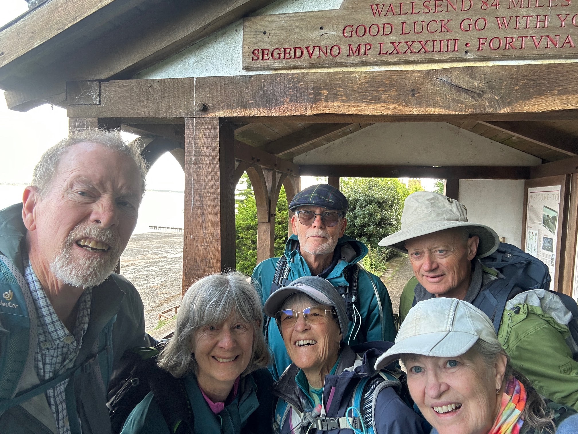
Our first stop was at the Banks Promenade, where we got our first stamp on our National Trail Hadrian's Wall Passport and took our starting picture. We had to take a selfie, which is no mean feat for a group of six, because there was no one around to take our picture. Then we began our longest day -- a walk of close to 16 miles. 

 The first part of the walk was along the coast of the firth, and we saw some signs warning us that the road could be under a foot of water during high tides. (Dave, our host in Bowness has assured us that the water wouldn't get close to the road, and he was, to our great relief, correct. We did see cattle being herded along the waterfront, and could look across the water to Scotland on the other side. 


Sometime of the trail was along roads and some went through fields. The trail got quite muddy in places, but we were never lost. Hooray for good signage! As long as we saw an acorn, we knew we were going in the right direction. 


We passed through  the hamlet of Drumburgh (pronounced Drum Bruff), where we encountered our first Honesty Shack. Honesty Shacks are little places set up by the locals that offer hikers snacks. Some (like this one) have a roof so it’s a respite from the rain and a few (like this one) have a toilet and a sink for filling water bottles. Others are nothing more than a cooler set out by the curb. None of them are manned: they trust you to be honest and put some money into a provided tin if you eat something. There are honesty shacks all along the first half of the walk, and I found them enchanting.


Drumburgh also has a castle, which is really not a castle at all. It's a 14th century a pele, or tower house. These were built to protect people and their good from reivers, people who came from over the firth to steal. It has extremely thick walls built with stones taken from Hadrian’s Wall, and the first floor was used as a barn, to protect cattle. 


We ate our sack lunches on a picnic table in a park in Burgh-by-Sands, a little town with a lot to recommend it. 
The Greyhound Inn was right next to the park, and looked to have nice offerings. Also in the park was a statue of Edward I of England, sometimes called "The Hammer of the Scots." Bus 93 passes through, so people who are too tired to go on can catch a ride back to Carlisle or to Bowness-on-Solway. Burgh-by-Sands was once the site of a Roman fort named Aballava, but all its stones have been taken and used in other building projects. 

Next, we stopped at St. Michael’s church, which is largely built of stones from Hadrian's wall. It is also where King Edward's body lay after he died  in 1307 while on his way to war against the Scots.


Sometime after that, the firth narrowed into a river, which we followed into Carlisle. It was a pretty walk, and we could tell by traffic noises that we were leaving the country and coming into an urban area. We walked through a nice city park in the last few miles, and ended at the Sands Center by Eden Bridge, where we were able to get our passport stamped once again.

We were tired by the time we got to Carlisle, and we knew that the next leg of our journey was also a long one, so we were glad that we'd seen the sites in this lovely town before we began our wall walk. 

Saturday, June 21, 2025

Walking the Wall: Getting to the Starting Place

When I was in the fourth grade, I read a book by Rosemary Sutcliff entitled The Eagle of the Ninth, a Young Adult novel set in Roman Britain one generation after Hadrian's Wall was built.Sutcliff based her story on the question of the Ninth Legion, also known as Legio IX Hispana, who were assigned to the northern provinces, and founded the cities of York, Leicester, and Lincoln before mysteriously disappearing from the historical record. She uses one theory for their disappearance, plus the 1866 discovery of a Roman sculpture of an eagle in the town of Silchester to craft a story about Marcus Flavius Aquila, a young Roman officer who chooses an assignment in Britain so that he can discover the truth about his father, who disappeared when he was very young. Disguised as a Greek oculist and accompanied by Esca, his British freed ex-slave, Marcus travels beyond Hadrian's Wall in an attempt to learn the truth and recover the Lost Legion's gilded bronze eagle so that it can no longer serve as a symbol of Roman defeat – and thus be a danger to the frontier's security. This book piqued my interest in Roman Britain and the Iron Age, and made me want to explore the frontier between England and Scotland.

This summer, I finally got to fulfill that long held dream. After fifty five years, I finally got to hike the length of Hadrian's Wall.  (What and where is Hadrian's Wall? Click here to find out.) I was joined in this grand adventure by my husband, two women who are hiking buddies of mine back home, and their husbands. I began planning the details of the trip eight months before we finally boarded a plane and began the adventure.

One of the first decisions I had to make was which direction we were to hike the 84 mile trail. Traditionally, people begin at Newcastle and hike west to Bowness-on-Solway, because that is believed to be the direction in which the wall was built. The milecastles, little fortlets that are built into the wall every mile, are numbered from east to west. Besides, getting to Newcastle is easy. It is a big city, and a hub for rail travel. It has an airport, and buses also come through, going in all four directions. However, I'd read that the prevailing winds came from the west, and that the views of the craigs, the most picturesque and dramatic scenery along the wall, was more stunning when seen looking east. So I chose to hike west to east, beginning at Bowness-on-Solway. 


Getting to Bowness-on-Solway, a little village that has just over a thousand people in it, was a bit harder. Located in Cumbria, the historic county of Cumberland, it lies on the southern side of the Solway Firth. Across the water lies Scotland. The nearest sizable town is Carlisle, some 15 miles to the east. We flew into Edinburgh, then took a train from Edinburgh's Waverley Station to Carlisle. The cost of tickets on the three carriers varies widely, and it is both advisable and cheaper to purchase them in advance. The 73 mile train trip took about an hour and a half. 

From Carlisle, we could either take a bus (the 93. You pay while boarding) or a taxi (there are several different companies to choose from. Uber also works in the UK) to Bowness-on-Solway. We chose the bus, since it cost £3 and a taxi (which we would have needed two of since there were six of us with luggage) can easily amount to £30. We had a few hours to kill before our bus was to depart, so we we stowed our luggage in a hotel close to the train station, using an app called Stasher and saw a few sites, which I'll share in a future blog.

Our bus ride proved to be quite the introduction to rural British roads. It's unsettling enough to be traveling on what feels like the "wrong" side of the road, but when the road is barely wide enough, it's really unnerving, especially when the traffic  going the other way seems to be coming right at you. Tall hedges bounded the road, making some of the travel feel like it was going through a green tunnel.
Fortunately, there were wide places in the road every so often, and drivers seemed to know exactly
where they were, so they could dart to the side as the bus barreled toward them. The only time the bus had to stop was for a herd of cows that didn't seem to understand that the bus outranked them. The bus driver waited patiently for the cows to move before hurtling on. Look closely and you can see the cows peering in the front windshield of the bus while my friend Caryl, who was right in front of me, laughs about it. 

We arrived in Bowness-on-Solway in the early evening and checked into Shore Gate House, a B&B in a beautifully preserved 17th century mill house that sat right on the water's edge. All six of us have agreed that this was the finest lodgings of the entire trip. The rooms were clean and well appointed, and each had its own bathroom. 
David and Linda were the kindest of hosts. David let us in, then sat us in a front parlor, where he gave us each a cup of tea. He sat with us and discussed our plans, giving us advice, especially about meals along the trail. His advice proved spot-on and saved us from having to go hungry more than once. He even called ahead and secured tables for us. 

We had dinner that night in The King's Arms, a very traditional little English pub that wasn't crowded, but still likes advance notice so they'll have enough food. Afterwards, we wandered through the town, taking in its quaintness and making sure we knew exactly where to start the next morning. Bowness is a town with a lot of history. Maia, the last of the forts along Hadrian's Wall was here. After the Romans left, its inhabitants were frequently raided by Scots who'd crossed the firth, and they in turn raided the Scots. Now, it is a sleepy and peaceful place. 


My traveling buddy Jane, reading a sign that describes the life of a Roman soldier, and standing on the shore of Solway Firth just after sunset. It was low tide. At high tide, she would have been waist deep in water. 

As I slipped into bed that night, I felt that I had made the right choice in starting out from this magical place. I couldn't wait for morning, to begin the trek I had wanted to do for so long.

Keeping Time with the Romans

  Modern societies rely on precise and standardized timing. Our schedules are synchronized to prevent chaos, ensure safety, and keep complex...